SCAN to BIM: the one with the triangular apartment
- cloudy.works

- Apr 18, 2023
- 4 min read
Updated: May 2, 2023
Part 1: Surveying Crooked buildings
I recall being assigned to survey a very crooked and very angular two-story house in London, using a tape measure, a sketch pad, and a pen. I had spent around three to four hours on site, with measurements contradicting each other and clients suggesting that it was time I went off.
At the end of the day, I was left with a scribbly sketch pad. No matter how many pictures and notes I took, the 'as-built' CAD drawings were far from accurate on their first go, and it took multiple visits to check and re-adjust the drawings of that psychologically tough renovation project; 'tough' only because of the uncertainty that the survey generated.
Even though that house in London was exceptionally crooked, buildings are rarely built exactly as drawn; usually, we see differences, offsets, and on-site alterations. Especially for renovation projects, where buildings have been modified through decades of use, it is critical to obtain the existing conditions before design.
Fast forward a decade - once again confronted with a less complicated but complex project: to quickly survey a triangular apartment in Nicosia to produce an accurate model on which the design will be based. However, this time around, I am equipped with a single and advanced tool - a Lidar scanner.
Instead of spending hours measuring and noting, I obtained a highly detailed and accurate 3D model of the space in a matter of minutes. The data we collected is precise, reliable, and allows us to create a flawless as-built model.

Part 2: The Joy of 360 Imagery
This project, although small-scale, is a good example of the benefits that scan to BIM methodology can provide, especially when it comes to surveying projects with challenging sites and geometries.
Regardless of how small the project is, the accuracy of the survey of each project is critical. Spending too much time on the survey of small projects will consume valuable time that might make the project unviable from a time/cost perspective. Scanning allows us to shrink the survey time consumption, stress, and accuracy-related issues to a bare minimum, regardless of the project size.
We talk of scan-to-BIM, but what about 360 Images-to-BIM? Is that even a thing?
The future role of 360 Images deserves to be explored when writing about scan-to-BIM methodologies. For those of us, that experienced missing that 'single image' that unlocks the finalization of drawings or models, 360 imagery feels like a superpower. These images are generated automatically by the lidar scanner and are used as an aid when making 'as-built' models or drawings.
But, there's more. When specialized software is involved, it becomes possible to generate BIM models by simply clicking on walls, ceilings, or openings directly into a 360 image viewer. We are hopeful that in the very near future, the modeling workflow will be less about modeling and more about overviewing the automated models that emerge from the synergy of 360 imagery and the accuracy of lidar data.
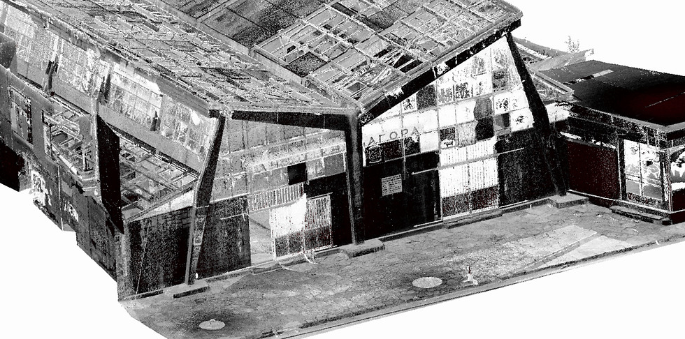
BIM modeling process video: making use of the 360 images the scanner provides to automatically
generate accurate geometry

Part 3: Out with the old, In with the new
Manual measurements are a thing of the past, and we're entering a new era of building documentation that's faster, more efficient, and more accurate than ever before. Scan to BIM isn't just a trend, it's the future. So, if you're facing an unconventional space, don't fret.
Here's an overview of what pivoting to a scan-to-BIM/CAD methodology means:
Accuracy: With scan-to-BIM technology, we can capture accurate measurements of even the most complex buildings and spaces. This ensures that the final deliverables are reliable and error-free, which is crucial in the architecture, engineering, and construction industry. Accurate data leads to better decision-making, which ultimately translates into better results for our clients.
Speed: Traditional measuring techniques can be time-consuming and tedious. With scan to BIM, we can gather data quickly and efficiently, which means we can deliver the final product to our clients faster than ever before. This saves time and money for everyone involved in the project.
Avoiding Mistakes and Construction Costs: One of the most significant advantages of scan-to-BIM technology is that it can help architects and engineers avoid mistakes and construction costs. By providing accurate data, we can identify potential issues early on in the design process, which allows us to make corrections before construction begins. This can save our clients thousands of dollars in construction costs and prevent costly delays or rework.
Improving Collaboration: Scan to BIM also improves collaboration between different stakeholders in a project. With accurate and reliable data, everyone can work from the same page and avoid discrepancies or misunderstandings. This leads to better communication, more efficient processes, and ultimately, better results for the project as a whole.
Future-Proofing Your Data: Finally, scanning to BIM provides a future-proof solution for building documentation. The 3D models and data we capture can be used for a variety of purposes, including maintenance and repair, renovations, and even future construction projects. This means that our clients can continue to use the data we provide long after the initial project is completed, which provides added value and cost savings over time.


Comments